News & Notices
-Click HERE for information regarding the Economic Impact Study 2020 of Rock Climbing in the Red River Gorge area. And info on the Red River Gorge Climber's Coalition annual reports.
Need a ride? Here are some shuttle services available in our area.
Daniel Boone Transit at 606-464-3859. Web Link.
Leave No Trace Adventures 606-362-7425. Web Link.
Three Forks Adventures 859-281-6033. Web Link.
Daniel Boone Transit at 606-464-3859. Web Link.
Leave No Trace Adventures 606-362-7425. Web Link.
Three Forks Adventures 859-281-6033. Web Link.
-Oh Nooo It's raining!! When it is raining and you want to climb, try out the new indoor climbing center at the Lee County Recreational Center located on Old Hwy 11, Beattyville, KY 41311.
Guided Services
If you are new to the area or new to climbing and rappelling, check out these climbing services that will take you into the wildlands of the public access areas for outdoor adventure in Lee County, KY.
The Rock Domain
The Rock Domain opened in 2018 and is a rock climbing, hiking, and camping area at the Cathedral Domain in Lee County. The Rock Domain boasts over 180 professionally bolted climbing routes raging from novice (5.4 routes) to world class (5.13 routes). A central parking and information area with access to trail heads means easy access to the climbing and hiking areas. The Rock Domain is located on Highway 1746, Irvine Kentucky. Turn off Highway 52 at the Cathedral Domain sign, drive up the hill, and follow the signs to the parking area. For more information visit www.cathedraldomain.org, or call (606) 464-8258.
|
| ||
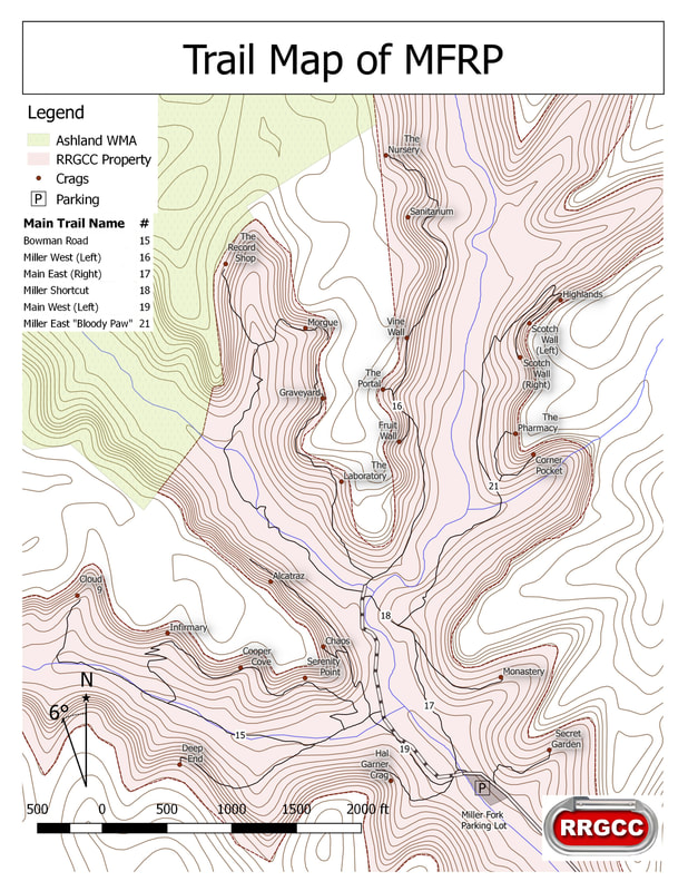
The Miller Fork Recreational Preserve
In June 2013, The Red River Gorge Climbers’ Coalition (RRGCC) with the help from Access Fund, purchased 309 more acres in Beattyville/Lee County, Kentucky. Named the Miller Fork Recreational Preserve, the land includes several miles of cliff line, some of which has been developed but with the vast majority of it awaiting discovery and development. There is potential for more than a dozen individual crags and hundreds of high-quality routes. The Miller Fork Recreational Preserve is located just seven miles from the popular Pendergrass-Murray Recreational Preserve (PMRP) climbing destination in Lee County, Kentucky. The Miller Fork acquisition creates a brand new destination for climbers in the region, helping to relieve the access pressures and climber impacts on other crags in the Red River Gorge.
“Like the PMRP, Miller Fork is going to change the game in the Red,” says Paul Vidal, President of the RRGCC. “Acquiring this property illustrates the strength of the climbing community in this region and its importance to the area. Without the community of climbers and businesses supporting us and pushing us to look to the future, we wouldn’t have been able to secure this climbing.” The purchase of the Miller Fork Recreational Preserve will be another step in securing access for climbers, while furthering the RRGCC’s mission of ensuring open, public access to ample, quality rock climbing opportunities. Like the PMRP, the RRGCC will own and manage the property in perpetuity.
Getting There
The Miller Fork parking lot, completed in the summer of 2014 with help from local oil and construction companies, is just before a wide creek on Hell Creek Road. Its GPS coordinates are 37°38'31.9?N 83°40'44.0?W (37.642204, -83.678900). To get there, travel 9.3 miles away from Miguel's towards Beattyville. Turn left on Shumaker Ridge Road and travel 3.5 miles down the road. Turn right on Hell Creek Road (no sign for the road) and go down a steep gravel road that is next to the Sunrise Mountain Retreat and Angel Falls Rd. There is a signpost for the MFRP, but occasionally it has been vandalized. Travel .8 miles down the hill. At the bottom of the hill turn right on the gravel road before the creek. Travel 1.2 miles down this road and the parking lot will be on the left. (Google Map)
Map of the MFRP
|
| ||
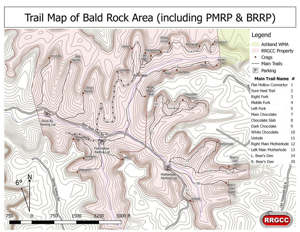
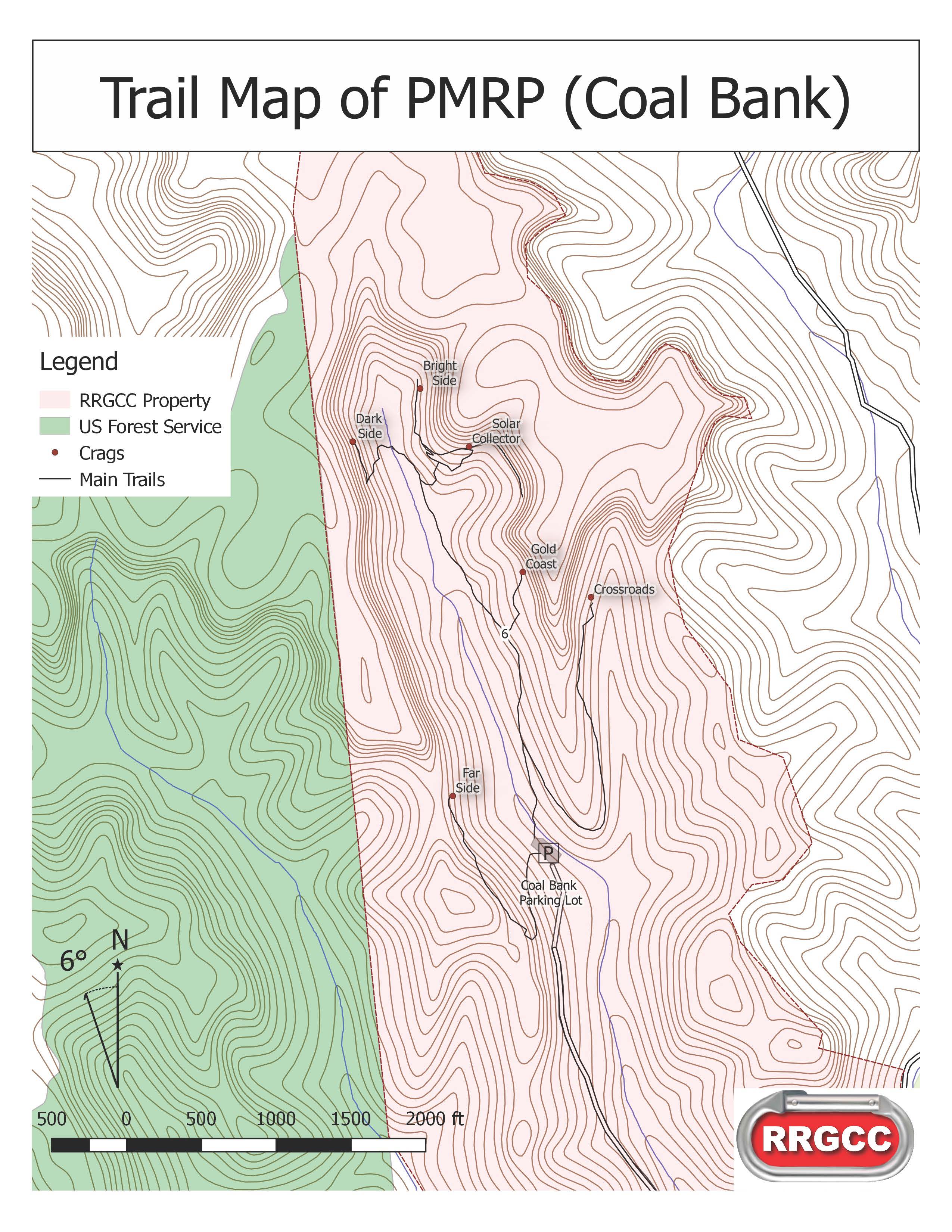
The Pendergrass-Murray Recreational Preserve
On January 20, 2004, the Red River Gorge Climbers Coalition purchased land in Lee County. This is a 750 acre track of land with gives private access to climbing just south of the Red River Gorge area. The Murray property was identified by the RRGCC as containing over 400 existing climbing routes and a number of quality cliffs to expand more routes of all difficulty levels. Since 2004, the land has been developed for public enjoyment though the creation of hiking paths, mountain bike trails, and of course more rock climbing routes. In October of 2012, the RRGCC made the final payment on the the land and it will forever remain open to climbing and other recreational activities.
Getting There
To get to the PMRP, travel south on KY 11 south of Torrent Falls. Depending on the area you're heading to, turn off on either Fixer Road to get to the Coal Bank Climbing area of the PMRP or Bald Rock Fork Road to get to the Motherlode, Bob Marley, Sore Heal, and Flat Holler locations of the PMRP. Park only in designated parking areas and steer clear of all oil production equipment. Check out the informational kiosks!
NOTE: Access to many crags in the PMRP may be problematical without a high-clearance vehicle.
Map of the PMRP (Bald Rock Region)
|
| ||||